
The last General Census of Agriculture, the 7th, was conducted in Italy in 2020. According to data collected by ISTAT, the National Institute of Statistics, there were 195,735 farms producing durum wheat at that time.
These farms have been categorized by province/region and altimetric range as follows:
- Plain: 0-299 meters
- Hill:
- 300-600 meters (for the Northern regions)
- 300-700 meters (for the Central-Southern regions)
- Mountain:
- > 600 meters (for the Northern regions)
- > 700 meters (for the Central-Southern regions)
By hovering the cursor over the regions or provinces, you can access aggregate information specific to the durum wheat producing farms, which includes:
- Overall farm size
- Area dedicated to durum wheat cultivation relative to the total area
- Average age of the farm manager
- Percentage of women in leadership positions
- Percentage of young farm managers.
The data used in this work are from Istat source and relate to the 7th General Census of Agriculture. The elaborations were conducted at the Laboratory for the Analysis of Istat Elementary Data and in compliance with the legislation on the protection of statistical confidentiality and the protection of personal data. The results and opinions expressed are the sole responsibility of the author and do not constitute official statistics. It should be noted that the analyses were conducted without using the weights reported to the universe.
For further details, please refer to “Durum wheat in Italy: where and who produces it“
Regional maps
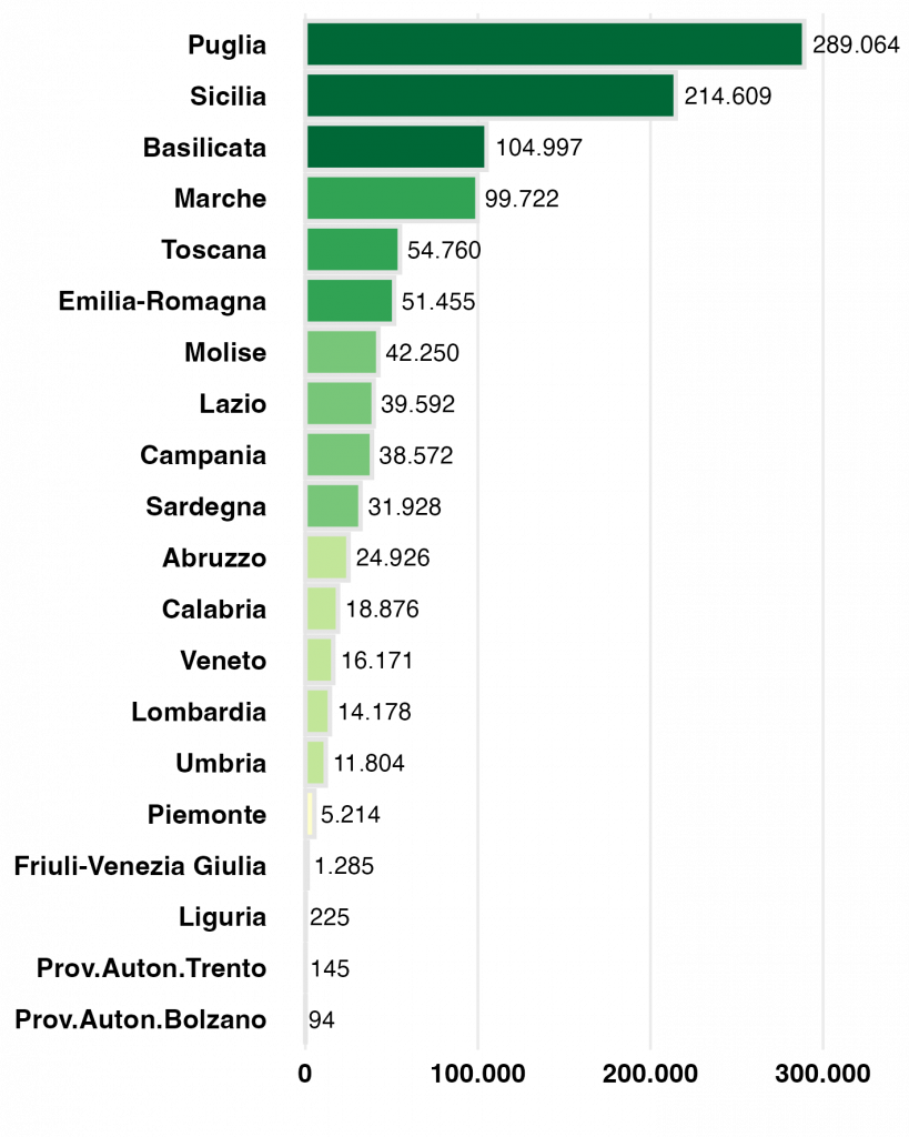
Puglia and Sicily: the hearts of production
Puglia stands out as Italy’s true “capital of durum wheat,” followed by Sicily.
Most cultivated areas are concentrated in the Central and Southern regions, ranging between 40,000 and 105,000 hectares per region, while Northern Italy plays a smaller role, with lower total acreage but higher mechanization and productivity.
Provincial maps
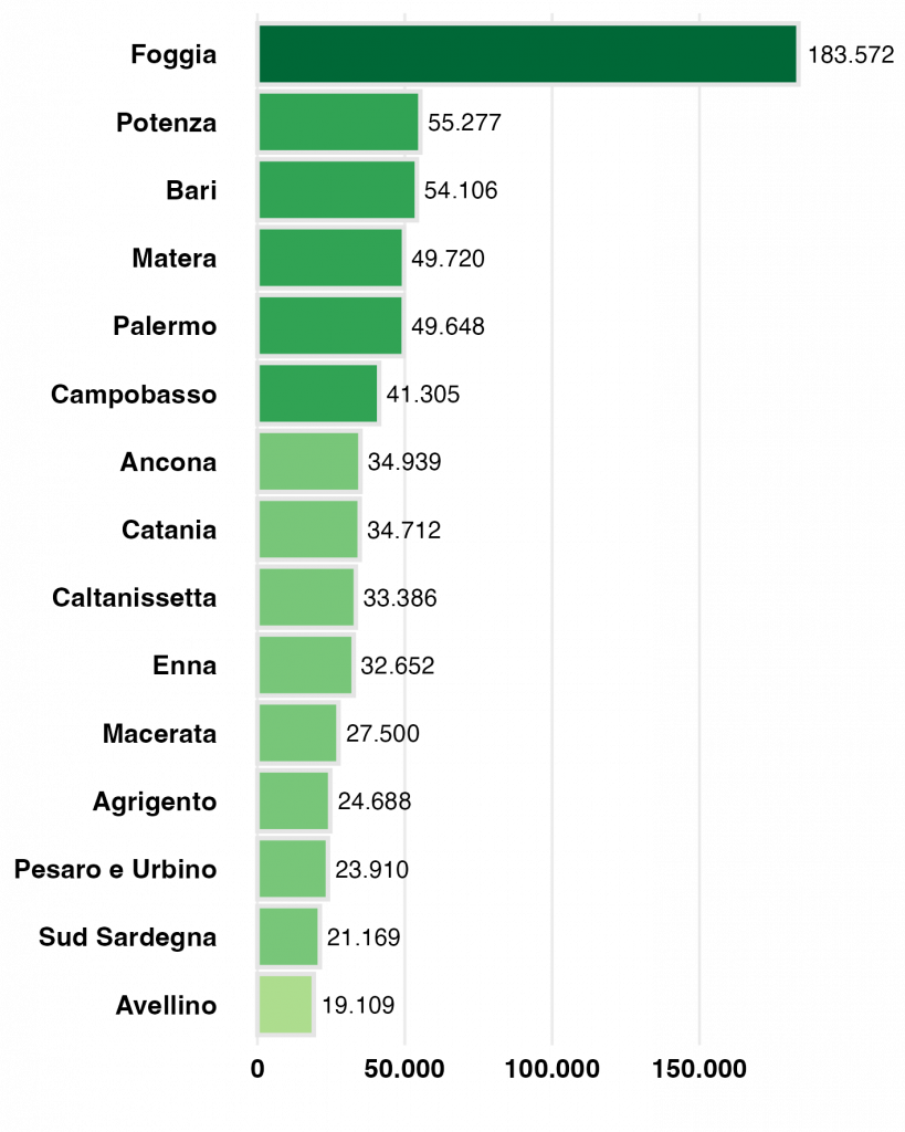
Leading provinces: Foggia ahead of all
At the provincial level, Foggia leads by far, with over 183,000 hectares cultivated — more than three times the area of the second-ranking province, Potenza.
Other major producers include Sicilian and Lucanian areas, but interestingly, Marche provinces such as Ancona, Macerata, and Pesaro-Urbino also show relevant surfaces, indicating a broader national distribution beyond Southern Italy.
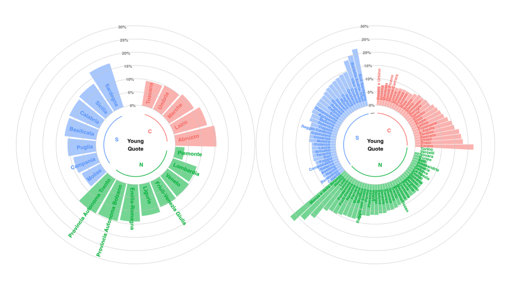
Who grows wheat: age and gender
The analysis also introduces a key socio-economic dimension: the profile of farm managers.
Women remain underrepresented, rarely exceeding 25% in the leading regions.
However, female presence is growing in areas such as Tuscany, Piedmont, and Marche, where wheat is often integrated into multifunctional farms combining production, agritourism, and local processing.
Young farmers (under 40) are still a minority, though more numerous in Southern regions and innovation-oriented areas, where CAP incentives and regional programs are fostering generational renewal.

Durum Wheat production
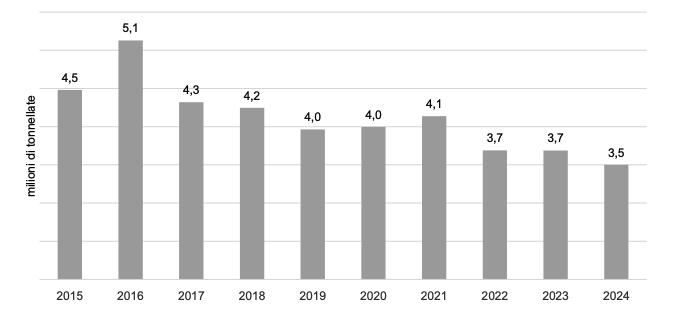
The average production in the decade 2015–2024 is equal to 4.1 million tonnes obtained from the cultivation of approximately 1.26 million hectares.
Source: ISMEA elaboration based on ISTAT data –Cereal Sector Report, ISMEA 2024